


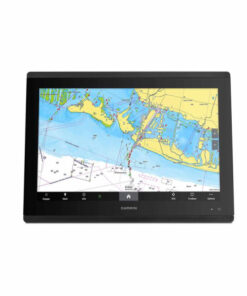


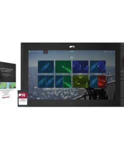
Garmin GPSMAP 8617 Chartplotter with Mapping
We have the Garmin GPSMAP 8617 Chartplotter for sale which delivers professional-grade performance in a sleek, easy-to-use 17″ multi-function display. Whether you’re a passionate angler, seasoned cruiser, or competitive sailor, this MFD offers unparalleled clarity, advanced sonar compatibility, and seamless connectivity across your entire vessel.
Equipped with a high-resolution Full HD IPS touchscreen, preloaded Garmin Navionics™ inland and coastal maps, and SmartMode™ station control, this chartplotter gives you everything you need for precision navigation and situational awareness — all in one rugged package.
Key Features:
Brilliant HD Touchscreen
-
17” Full HD IPS display (1920 x 1200) with ultra-wide viewing angles
-
Sunlight-readable, even with polarized sunglasses
Preloaded Garmin Navionics™ Maps
-
Integrated inland & coastal mapping
-
Auto Guidance+™ routing with 1-year of daily map updates
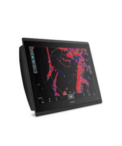
Built-In Sonar Support
-
1kW CHIRP traditional sonar support
-
ClearVü™ and SideVü™ scanning (requires GCV™ black box)
-
Panoptix™ and LiveScope™ compatible (sold separately)
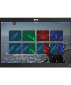
Customizable SmartMode™ Station Controls
-
One-touch access to sonar, radar, cameras, and more
-
Helps reduce stress during docking or emergencies
Garmin Marine Network & NMEA Connectivity
-
Share radar, sonar, maps, user data across multiple displays
-
Compatible with NMEA 2000® and NMEA 0183 networks
Next-Level Sailing Tools
-
SailAssist™ features like laylines, wind data, race guidance
-
Sailing polars to optimize performance and trim
Connectivity You Can Count On
-
Built-in Wi-Fi®, Bluetooth®, and ANT+®
-
Compatible with ActiveCaptain® app for smart notifications, Helm view, updates & more
-
Supports remote control via GRID™ 20 and wireless remotes
Garmin GPSMAP 8617 Chartplotter Specifications:
| General | |
|---|---|
| Display Size | 17.0” diagonal (1920 x 1200) |
| Dimensions | 16.5″ x 12.1″ x 2.8″ (41.9 x 30.7 x 7.1 cm) |
| Display Type | FHD IPS touchscreen |
| Weight | 11.48 lbs (5.21 kg) |
| Waterproof Rating | IPX7 |
| Mounting Options | Flush or flat mount |
| Power & Connectivity | |
|---|---|
| Power Input | 10-35 VDC |
| Max Power Consumption | 40W |
| Garmin Marine Network | 4 ports |
| NMEA 2000 / NMEA 0183 | Yes / Yes |
| Video In/Out | 2 in (BNC + HDMI), 1 out (HDMI) |
| USB, Wi-Fi, Bluetooth, ANT | Yes |
| Memory & Mapping | |
|---|---|
| Accepts Data Cards | 2 SD card slots |
| Waypoints / Routes | 5000 / 100 |
| Tracks / Trackpoints | 50 / 50,000 |
| Built-In Maps | Garmin Navionics™ |
| Optional Maps | Navionics Vision™, Quickdraw™, TOPO |
Benefits:
-
All-in-One Navigation: Combines chartplotting, sonar, and network control in one device
-
Superb Visibility: IPS display provides outstanding readability in any conditions
-
Modular Flexibility: Add sonar modules, radar, cameras, and digital switching easily
-
Remote Access: Use your smartphone or GRID remote to control your system
-
Future-Proof Integration: Fully compatible with the latest Garmin tech and third-party devices via OneHelm™
What’s in the Box:
-
Garmin GPSMAP 8617 MFD
-
GPS 24xd NMEA 2000® Antenna
-
Flush Mount Kit & Trim Piece Covers
-
Protective Cover
-
Power Cable
-
NMEA 2000 Backbone & Drop Cables
-
NMEA 2000 T-connector & Terminator Kit
-
Documentation
Frequently Asked Questions (FAQs):
Q: Is the Garmin GPSMAP 8617 compatible with LiveScope sonar?
A: Yes, it is compatible with LiveScope and other Garmin Panoptix sonar systems (transducer sold separately).
Q: Can I connect this to my radar and autopilot system?
A: Absolutely. The GPSMAP 8617 integrates seamlessly with Garmin radar, autopilots, VHF radios, and more via NMEA 2000 and Garmin Marine Network.
Q: Does this model include maps for inland lakes and oceans?
A: Yes, the device includes Garmin Navionics™ inland and coastal maps, with Auto Guidance+™ and a 1-year subscription to daily map updates.
Q: Can I control it with a smartphone?
A: Yes, through the ActiveCaptain® app, you can control features, receive smart notifications, and update software wirelessly.


Reviews
There are no reviews yet.